Batticaloa Lagoon and Its Estuarine Flow
Batticaloa District is part of the Eastern Province of Sri Lanka and Batticaloa Town is the seat of the District Administration. The District Secretariat and the District Heads of other Departments are located in the Batticaloa town.
BATTICALOA LAGOON
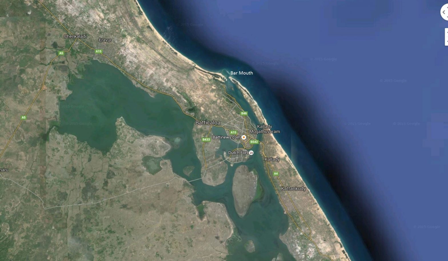
Batticaloa Lagoon is a very large estuarine lagoon in Batticaloa District, of Eastern Sri Lanka. The city of Batticaloa is located on a narrow stretch of land between the lagoon and the Indian Ocean. Batticaloa District is flourished with three lagoons, such as Batticaloa lagoon, Valaichchenai Lagoon and Vakari Lagoon. Among them, Batticaloa lagoon is the largest lagoon in Batticaloa District. Batticaloa lagoon is a long and narrow lagoon situated in the eastern coast of Sri Lanka with the total area of approximately 11,500 ha of water.
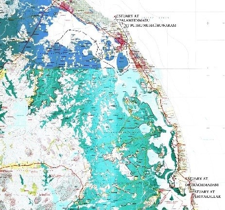
The lagoon is 56 km long. This lagoon extends from Eravur (Batticaloa District) in the north to Kalmunai (Ampara District) in the south. This lagoon opens in to the sea at two points. One in the southern end of the lagoon – two pronged – at Onthachimadam and Kallar and the other is midway of the lagoon at Palameenmadu near the light house which is close to the Batticaloa town. Both are narrow and approximately 200 m wide.
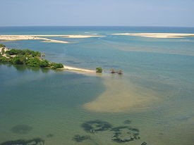
Batticaloa Lagoon opening at Palameenmadu.
The width of the water flow at their openings varies with the seasons. During the dry season the width of the bar mouth of the lagoon decreases and gradually it get closed with the onset of the north east monsoon which piles up the sand bar by the end of dry season. Later with the rains and with the lagoon mouth closed.
The lagoon is fed by a number of small streams. It is linked to the sea by a two narrow estuaries, one at Batticaloa and the other at Periyakallar. During the dry season these estuaries are blocked by sand bars.
(Extract from Wikipedia)

THE BATTICALOA LAGOON AND THE ESTUARINE FLOW
The Lagoon acts as an intermediate on Interim Retention Area for the inflow of water from the catchment area. The main river in the catchment is Mahilawattuwan River which has its origins in the hilly areas of Uva Province. The catchment area of this river is 274 Sq.km. (105.60 Sq.miles) and all the rain falling in this area flows through this river. The river feeds the Unnichchai Reservoir before it flows in to the lagoon closer to Karaveddy village on the western side (Paduwan Karai). . The other main river is the
Manalpitty Aru which feeds Puluganawa & Kadukkamunai tanks. In addition to these main rivers there are other minor streams flowing in to the lagoon.
There are four major crossings across the wider and deeper section of the lagoon at VALAYARAVU, KALLADY, MANMUNAI and PADDIRUPPU. In addition to these major crossings there are minor crossings at SAVARITHURAI, PUTHUPALAM and KOTTAMUNAI. There are also two crossings along Batticaloa Kalmunai road near the estuary at Onthachchimadam and Kallar.
VALAYARAVU BRIDGE
The Bridge has 6 spans of 75’11” and 2 spans of 62’ 6” and Rubble Filled Causeway, constructed during 1973-1977. This Bridge connects the Underdeveloped Western shore of the Lagoon to Batticaloa town.
KALLADY BRIDGE
The original Steel Truss Bridge was constructed during the colonial period and has 6 spans of 158ft each. A New Concrete Bridge which is 288.35 meter long, with post tensioned beams has been constructed recently in 2013 parallel to the old steel bridge and has six spans of 48.05 meter each. Kallady Bridge is along the main road to the south of Batticaloa and connects the strip of land between the sea and the lagoon.
MANMUNAI BRIDGE
This 210 m long Bridge is south of Batticaloa and was constructed during 2014 connecting the coastal strip to the western shore of the lagoon. This is a concrete bridge with 6 spans of 35 m each.
PULIYANTHEEVU
The Puliyantheevu which is the main Batticaloa town is connected by KODDAIMUNAI BRIGE and PUTHUPALAM to the main land and by SAVARITHURAI (Sumai Thangi) to Sethukkudah and beyond by VALAYARAVU BRIDGE to the Mainland. A very effective and practical system has been put in place with appropriate Spans for the Bridges and protective Bunds across the lagoon at various points to Ensure Natural Flow through the deeper part of the lagoon. It is very essential that this path is not disturbed and deviated and led into the shallow lagoon between Puliyantheevu and Koddaimunai and thus making Batticaloa town and its population exposed to flooding and displacement.
SAVARITHURAI
SAVERITHURAI Crossing has always been an Earthen BUND (SUMAI THANGI) to ensure and direct the flow path along the deeper and wider section of the lagoon around BUFFALO ISLAND and under the KALLADY BRIDGE which has long spans to cater to the huge lagoon flow. This Bund also prevents the lagoon water from entering the small and shallow area of the lagoon within the Batticaloa Town which has only small bridges namely PUTHUPALAM and KOTTAMUNAI BRIGE each with only 2 spans of 20ft each as lagoon crossings, which cannot cater to the flow from the western side of the lagoon. The Savarithurai Bund also protects the Batticaloa Town from flooding. During my last visit I found that a low level causeway had been introduced encouraging the lagoon water to flow in to the small lagoon area. This causeway is having an adverse effect on the main path of flow of the lagoon to the sea. This was one of the main reasons why the Main Bus Stand in the Batticaloa town got flooded. The Main Path of Flow of the Lagoon is marked by Black Arrows along wider and deeper section of the lagoon and under the Kallady Bridge toward the Palameen madu Estuary. It is ESSENTIAL to REINSTATE Savarithurai to its Original Level.
KODDAIMUNAI BRIDGE
As explained earlier the RISE of water level in small lagoon area within Batticaloa town is MORE due to Backing up of the lagoon from the Kallady Bridge side which is the main path of flow in to the sea. The Koddaimunai Bridge opening should be kept as it is and should not be increased. If it is increased more water will flow in to the small area of the lagoon which will affect the Batticaloa town and all the low lying land adjoining the lagoon in Puliyantheevu & Koddaimunai will go under water and most of the people have to be displaced during rainy season.
PUTHUPALAM (on Kannaki Amman Kovil Rd)(RDD)
This Bridge cum Causeway was constructed during the peak of the Conflict when people were finding it difficult to pass through Koddaimunai Bridge because of the location of the Main Police station being adjacent to the bridge. This Bridge was constructed with funds from Decentralised Budget and was designed to have 2 spans of 20 feet, same as the Koddaimunai Bridge. In addition to the Bridge Rubble Filled Causeway was also provided to cater to additional flow. The flow area through the Puthupalam (Bridge cum rubble filled Causeway) is more than the flow area of Koddaimunai Bridge). PUTHUPALM was constructed at a very low cost and even the widening of the Kottamunai bridge cost many times more the cost of Puthupalam. This also acts as an Alternate Road for the main traffic by passing the crowded and congested town road.
SMALL & SHALLOW LAGOON AREA WITHIN BATTICALOA TOWN
This is the area of the lagoon between SAVERITHURAI and PUTHUPALAM and KOTTAMUNAI BRIDGE which is very small and less than 1.5% of the total lagoon area with no rivers or streams flowing in to it. It is only the rain water from a small section of the town that flows in to this lagoon area. The main flow in to this small lagoon area is the water backing up from the Kallady Bridge. One can observe the TIDE and EBB Flow under the Koddaimunai Bridge and Puthupalam due to the Tidal variation. It is indeed very wrong to presume that flow from this miniscule part of the lagoon will have any impact on the estuarial flow. This SHALLOW CALM part of the lagoon is the spawning area for prawns, crabs, fish and other marine life and should be allowed to remain without allowing excess and extreme flow disturbing and upsetting the spawning process. It would be ideal and help the marine life if fishing is REGULATED in this part of the lagoon. A total PROHIBITION may even be better.
CUTTING OPEN THE SAND BAR
The main estuarial flow is through Palameen Madu near the Batticaloa Light House. In the past it was the responsibility of the then PWD (Public Works Department) and later Highways Department and the Road Development Authority (RDA) to cut open the sand bar at Palameen Madu. There are Standing Orders regarding the cutting of the sand bar. According to the Standing Orders the bar can be cut only when the lagoon reaches a certain level {3.0 feet or 0.9144 metre above Mean Sea Level (MSL)}. Normally only narrow channel is cut to connect the Lagoon and the Sea. The Head difference between the Lagoon and the Sea gives the required momentum to WIDEN and DEEPEN the estuarial channel to the sea. If we attempt to cut the bar before it reaches the level prescribed in the standing order the estuarial channel will not widen and deepen and as a result sea mouth will close within a short period. If even after opening of the bar at Palameenmadu heavy rain persist and water level in the lagoon RISES RAPIDLY then the second opening can be made at the DUTCH BAR to cater to the excess flow in to the lagoon but this situation is very rare.
ESTURAY REMAINING OPEN
Nature has its own mechanism to get the lagoon clear of sand silt collected in the lagoon. The CYCLONE (1978), the TSUNAMI (2004 Dec.26 ) helped to clear the lagoon of the silt and sand and helped to KEEP the Estuary open for a longer period. It has been observed that POST CYCLONE and POST TSUNAMI when the estuary remained open for longer period the population of marine life in the lagoon thrived and there was a bumper harvest of Fish, Prawns and Crabs and gave a fillip to the fisheries industry in Batticaloa.
It is observed from practical experience that DREDGING the lagoon and removing the silt and sand brought in to the lagoon from the catchment helps to keep the estuary open for much longer period to help the promotion of marine life.
In the eighties dredging was carried out using the dredger from the Land Reclamation Board. This was made possible with the help of the then G.A. and the funds released from the Ministry of Regional Development. This exercise helped to keep the estuary open for a longer time and thereby helped to give a boost to the fisheries sector which is one on the major economic component of the Batticaloa district.
The Dredging of the lagoon will also help in reclaiming some of the low lying areas in Batticaloa using sand removed from the lagoon. During the dredging in the nineteen eighties the authorities were able to reclaim a large area of low lying marshy land between the Municipal Council premises and Yard Road., which has been used to construct the new library and a playground. The excess sand also was used by the construction industry and land for filling. Most of the cost of dredging can be recouped from selling the sand dredged from the lagoon. The Batticaloa lagoon is one of the major lagoon in Sri Lanka and merits stationing of a Dredger on a permanent basis. This will help in increasing marine population in the lagoon and thereby increase the income from the Fisheries sector.
SUGGESTIONS
- REINSTATE SAVARITURAI TO ITS ORIGINAL POSITION
- ARRANGE A DREDGER TO BE STATIONED IN THE BATTICALOA LAGOON ON A PERMANENT BASIS
- REGULATE OR PROHIBITFISHING IN THE SHALLOW LAGOON AREA WITHIN THE BATTICALOA TOWN